Interests — Aviation
Flying the Hudson River
This page discusses rules, regulations and best practices for flying light aircraft on the popular sightseeing route of the Hudson River, passing through the metropolitan New York City area. The instructions are intentionally verbose and try to include all of the things a prudent pilot should know about before flying in the area.
Originally published in the early 2000s and updated for current procedures, I've recently reviewed operational information as of August 2026, such as rules, charts, frequencies, NOTAMs and temporary restrictions. However, these things of course change. Always use current FAA sources for actual flight planning.
Disclaimer
I’m not a flight instructor, FSDO or FAA official. I’m a local pilot and have seen a lot of requests on bulletin boards, etc. from pilots wondering about flying in the area. So I’ve put together these pages. I don’t guarantee accuracy or currency. YOU are responsible for your own navigation and FAR compliance. These pages may have TOO much information. But I’ve tried to put this together for someone who may be wholly unfamiliar with the area. Everything in here assumes that you’ll get the appropriate charts and take some time digesting all this. It’s MUCH easier than it looks in text. But I’m trying to include everything.
Why Fly the Hudson?
The whole Hudson Valley, NY from Albany right down past the Verrazzano Narrows Bridge is amazing. The difference in terrain from countryside to small cities to New York City represents contrast, history and huge seasonal variety.
What Changed: Today’s SFRA
When I originally wrote these pages, this stretch of river was simply “the VFR corridor.” After the August 2009 midair collision over the river, the FAA formalized more aspects of the route: since November 19, 2009, the area is the New York Class B Airspace Hudson River and East River Exclusion Special Flight Rules Area (14 CFR Part 93, Subpart W). The character of the flight is the same. The rules are now regulation rather than charted advice:
- Indicated airspeed no more than 140 knots.
- Anti-collision and position/navigation lights on (if equipped); landing light recommended.
- A current New York TAC and/or New York Helicopter Route Chart on board, and be familiar with it.
- Transient flights (running the river end to end): at or above 1,000 ft MSL, below the 1,300 ft MSL Class B floor. Local operations (sightseeing circuits and the like) stay below 1,000 ft MSL.
- Southbound: west shoreline. Northbound: east (Manhattan) shoreline. Same as it always was. Stay right, like driving in the U.S.
- Self-announce on the Hudson CTAF 123.05 at the charted mandatory reporting points These include: Alpine Tower, George Washington Bridge, Intrepid, Clock (Colgate Clock), Statue of Liberty, and VZ (Verrazzano-Narrows Bridge). Give aircraft type, position, direction, and altitude. FAA’s example: “Cessna, GWB, 900 feet, southbound.”
- Circling the Statue of Liberty: highest practical altitude below 1,000 ft MSL, counter-clockwise, and watch for the tour helicopters working an irregular pattern around 500 ft.
- The East River is now off limits to fixed-wing aircraft unless ATC authorizes it. Call LaGuardia Tower (126.05) before Governors Island. (Seaplanes landing and departing the river are the exception and anyone doing that likely knows the rules.)
- Want to go over the top instead? The charted Skyline Route is a Class B VFR transition up the river at 1,500–2,000 ft. Get your clearance before the Verrazzano northbound (Newark Tower, 127.85) or before Alpine Tower southbound (LaGuardia Tower, 126.05). This is a fine way to fly through VFR if you're just passing through. It keeps you out of the mess, and higher up which is almost always better just in case you do have any issues.
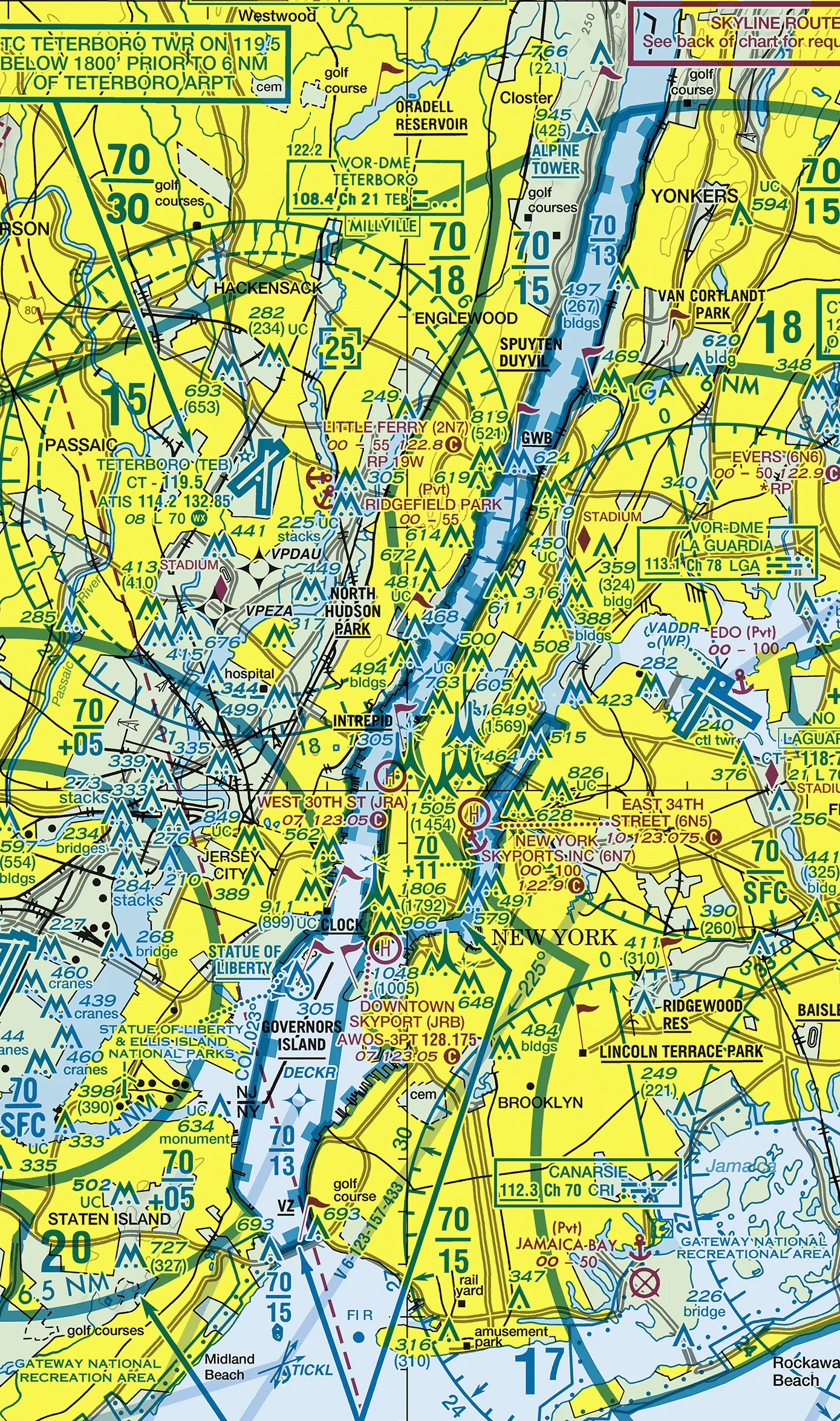
Here's a chart excerpt. The obvious disclaimer; this is just a picture in time. You need to have your own updated chart. This could be outdated the next cycle after I post it, or years later if I don't happen to get around to updating it.
What Are the Major Risk Issues of Flying the Hudson River?
- High traffic density with some tight airspace restrictions. Starting from Albany down there are multiple small airports on both sides of the river. In the Newburgh area, these include Stewart (SWF), (which as a dual use airport will occasionally have military traffic in the form of helicopters and transport category aircraft). On the other side of the river is Dutchess County/Poughkeepsie (POU) airport. Continuing south down the Hudson, you’ll pass the restricted area over West Point Military Academy (R-5206) which may or may not be active depending on when you pop over. Next will be Westchester County airport (HPN), a busy NYC reliever airport just to the east. Shortly thereafter, you will find aircraft zigging and zagging their way among the various approach routes to all three major NYC airports (Kennedy, LaGuardia, and Newark Liberty), in addition to other New Jersey side smaller airports such as Teterboro (which is smaller than the majors, but hardly “small”). Next will be the West 30th Street heliport on Manhattan’s west side until you are finally “released” towards the lower bay area past the Verrazzano Bridge. (At which point you can begin looking out for some restricted airspace around some New Jersey military airfields.)
- Pilots unfamiliar with area/procedures. If you’re here and reading this, you’re not the sort that’s likely part of the problem. But as you might imagine, some don’t gather “all information pertaining to the flight.” Some gather only “information pertaining to the flight that’s really easy to get with little effort and expense.”
- Violation of existing airspace. As with any major metropolitan area, there exist significant airspace restrictions in the form of Class B zones, various Class D locations and some restricted areas as well.
- Violation of NOTAM airspace. As a major metropolitan area, there are occasionally incidents (such as a fire or other disaster) which would result in a NOTAM.
-
Violation of TFR areas. Even before the
9/11 terrorist attacks, NYC would occasionally be subject
to flight restrictions due to Presidential or some other
dignitary’s travel. This can result not only in
airspace restrictions, but sometimes temporary closing of
airports such as Westchester County.
NOTICE: The north part of the Hudson River Exclusion can fall within the standing stadium TFR during a Yankees game — Yankee Stadium sits in the Bronx just a bit southeast of the George Washington Bridge. The blanket sporting-event restriction (currently FDC NOTAM 4/3621) covers stadiums of 30,000+ seats from one hour before until one hour after the event. So checking for TFRs should include checking whether there’s a Yankees home game the day or evening you intend to fly this area. - Violation of Common Sense. As a light aircraft pilot, you’re aware that 99.9% of the paranoia regarding terrorist risks due to light aircraft are wholly bogus. Nonetheless, the groundlings have their media induced fears. When flying the area, act like a sightseer, not a stalker. The vague government directives to not “loiter” over certain areas such as landmarks, etc. are sensible if only to not cause the uninitiated to seek out even more restrictive regulations. And the reality is “bad” behavior in this area very well could result in an intercept. More likely from New York City or Coast Guard helicopter than from military jets, but nonetheless, it’s possible and more likely if you do something foolish like overstay your welcome orbiting landmarks, etc.
- There is basically no place to safely land. There are some piers that seem empty. Not real sure how stable they are. There’s a couple of parking lots on the New Jersey side of the river. Basically, you’re probably going in the water if you have a power plant failure or you’re going to bend metal in the few poor land based spots where you could even think about trying to settle in. If you must ditch, your most significant consideration will be to do so somewhere along the way you’ll be able to get out of the river. That is, close to shore where there’s a means to get dry. There’s plenty of places where the riverbank is not amenable to easily climbing out. The Hudson also has a current of up to several knots, which in some places can even be running UP river. (Technically, it’s not even a river at all in some places, it’s a “tidal estuary” and is very much subject to tidal changes.) If you end up swimming, just try to go directly to the side and float to where you can get out, wherever the current is taking you.
Still coming? Good. It’s fun. Here’s some quick things you should know or have first.
Charts
- REQUIRED for the Hudson/East River Exclusions
- New York VFR Terminal Area Chart (TAC) — a current TAC, or current New York Helicopter Route Chart, must be available in the aircraft under today’s SFRA rules (14 CFR 93.351), and you must be familiar with the information it contains.
- New York Helicopter Route Chart — may be used instead of, or together with, the TAC. It gives a particularly detailed picture of the NYC helicopter-route environment. (Remember the East River itself is no longer a fixed-wing option without ATC authorization; see above.)
- ALSO USEFUL
- New York Sectional — useful for broader-area VFR planning, arrivals/departures and the surrounding airspace, although it is not the chart specifically mandated by the Hudson/East River Exclusion rule.
Current Airspace Info
- Briefing
- Besides the obvious weather info, you simply MUST check for any brand new TFRs. (When I first wrote this, “DUAT” was the way; that service is long gone. Today it’s Leidos Flight Service at 1800wxbrief.com, your EFB app of choice, and the FAA’s TFR list.) If launching from a local airport, it might be good to phone up just before launching and ask for an “abbreviated briefing” covering any fresh TFR or NOTAM information in the metro NYC area. The point of the supplemental call is really just to be on tape indicating you otherwise have the appropriate information. If something does ‘pop up’ after you depart, at least when it comes time to talk to the FAA, you can show that you had done everything prudently possible in terms of getting all information pertaining to your intended flight.
- TFRs
- The usual need to not loiter over points of interest or places with security concerns (e.g. nuclear power plants, landmarks) remains a wise thing to respect.
- And I’ll repeat the stadium warning from above: Yankees home games put the north end of the river under the standing sporting-event TFR from an hour before to an hour after the game.
How the Locals Do It (or Should Be, Anyway)
Whether you’re going within the Class B or staying in the Exclusion…
- Have the VFR chart out and folded appropriately (or the EFB page loaded — but the current chart still has to be on board).
- Stay on the WEST side of the river if going SOUTHbound “DOWN” the river, or stay on the EAST side of the river (Manhattan side) if going NORTHbound “UP” the river. (Basically, same as U.S. auto driving. Stay on the right. This is now regulation, not just custom.)
- Have the appropriate self-announce frequencies dialed in. Even if you’re going via ATC control through Class B, it can’t hurt to monitor who else is around if you have that capability.
| Hudson River | 123.05 |
| East River | 123.075 |
| Emergency/Guard | 121.5 |
| If you’re intercepted, this is likely how they’ll try to contact you via radio. | |
| NY Approach | 126.4 |
| Before getting into the lower areas (for example, south of the Tappan Zee Bridge — officially the Gov. Mario M. Cuomo Bridge since 2018, though nobody local calls it that), it can be useful to monitor NY Approach if you’re not actually talking to them for flight following anyway. You’ll at least hear other traffic calls and perhaps yourself being called out as a target for others. (Confirm current sector frequencies on today’s chart.) | |
Per the rules (charted guidance when this was written; 14 CFR 93.351 now):
- Do not exceed 140 knots IAS.
- Turn on anti-collision and position/navigation lights; landing light recommended.
Going via the Class B
- If ATC isn’t too busy, and depending on what approaches are in use at the major airports, you might just get a clearance. In fact, unless they’re truly busy, you should get what you ask for. (For the river itself, there’s now also the charted Skyline Route — see the SFRA section above.)
- Do NOT be afraid of NY ATC. They’re ok folks just doing their job. Assuming there’s no special security in place, you may even enjoy visiting the NY TRACON in Westbury, Long Island sometime. In any case, as you might expect, you want to try to get into the system a bit early so as to not be moments from penetrating Class B before you call in. A couple of these guys do have the NY accent thing going on. Don’t worry. They won’t hurt you. And I know you know this, but… remember, you do need to hear the Magic Words, “Cleared into or through or whatever the Class B.” If you don’t hear the words “Class B” confirm well before you cross the line.
- Monitor the appropriate frequency first and make your request quick and clean. (Obviously, if you’re hearing other folks being denied flight following due to workload and Class B requests, don’t bother.)
- “Quick” doesn’t mean you have to adopt NYC speed talk. It just means you have clarity in what you’re going to say and you deliver your request without a lot of thinking you should have done before you started talking.
- Here’s an example of a call-in request: “New York Approach, Bugsmasher 123, Croton Point, two thousand, request Class B clearance down Hudson to Colts Neck VOR.” (Or “down Hudson to the Lady and back” - “the Lady” being a common local designation for the Statue of Liberty.)
- You probably don’t even need the “Colts Neck” (VOR) or a destination, but giving this avoids the controller having to ask you your destination. Sometimes they ask this, sometimes they don’t. Why and when they need this information to some degree depends on what you ask for and from which sector you’re approaching. Can’t hurt to throw it in though.
- Alternatively, of course, you can always just use the super abbreviated “New York Approach, Bugsmasher 123, request.” When they call you, you’ll know you have their attention. (Which is no excuse for an overly drawn out request in any case, but you’ll know it’s your turn.)
- You MUST get the VFR chart and see for yourself, but some good places to call in to request your clearance might be…
| North | Frequencies |
|---|---|
| Croton Point. 7nm north of the Tappan Zee bridge and
just north of the Sing Sing prison checkpoint on the VFR
chart. (Even though Sing Sing is the official checkpoint
flag on the VFR chart, I can’t remember ever
hearing anyone use it in the years I’ve been flying
around here. They know where Croton Point is.) WARNING: HPN approaches may be headed toward Rwy 16 around here and a lot of VFR traffic is being sent to the Tappan Zee prior to going inbound HPN. Traffic may be crossing the river west to east and descending to a pattern altitude of around 1500′ or climbing out east to west. |
126.4 127.65 |
| Northeast | Frequencies |
| Norwalk. If you’re coming down the coast, you can call here for flight following, but you still have a ways to go to get to the Hudson. You’ll also need to watch out for Westchester County Class D airspace. | 126.4 |
| South | Frequencies |
| Colts Neck VOR, Sandy Hook. WATCH IT! Class B floors come down fast out here over the water — check the current TAC for today’s exact shelves. | 127.4 |
| West | Frequencies |
| If you’re tooling around VFR, this is an interesting direction to come from. Between Essex County and Morristown airports’ Class D airspace areas followed by Newark and Teterboro… well, unless you’re somewhat familiar with the area, this would not be the suggested easy sightseeing approach. |
- Be ready to take notes. You’ll get a squawk code just as you typically would for flight following or Class Whatever airspace tracking, but in this neck of the woods you’ll also be switching frequencies several times within a very short time span.
- Going via the Exclusion (no Class B clearance necessary): follow the SFRA rules above — altitude band, shorelines, CTAF 123.05, and the mandatory reporting points — and see the Hudson River Route & Checkpoints page for the north-to-south details.